رغم مرور أكثر من أربعة عقود على معركة الشقيف الشهيرة، لا تزال القلعة تحتفظ بمكانتها كواحدة من أهم النقاط العسكرية في جنوب لبنان. ومع كل تصعيد أو مواجهة في المنطقة، تعود إلى الواجهة باعتبارها موقعاً قادراً على التأثير في ميزان السيطرة الميدانية بفضل موقعها الجغرافي وتاريخها العسكري الطويل
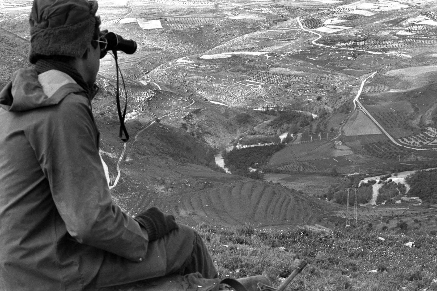
وتُعدّ قلعة الشقيف من أهم المواقع الاستراتيجية في جنوب لبنان بسبب موقعها الجغرافي الفريد. فهي تقع على ارتفاع يتجاوز 700 متر فوق سطح البحر، ما يمنحها قدرة استثنائية على الإشراف على مساحات واسعة من الجنوب اللبناني وشمال فلسطين المحتلة. ومن على أسوارها يمكن مراقبة نهر الليطاني وعدد كبير من القرى والبلدات الجنوبية، إضافة إلى المحاور الرئيسية التي تربط بين النبطية ومرجعيون والقطاع الشرقي من الجنوب
كما تطل القلعة بشكل مباشر على مناطق أرنون وكفرتبنيت ويحمر وزوطر والطيبة ودير سريان والقنطرة، فضلاً عن مستوطنة المطلة الواقعة على مسافة تقل عن أربعة كيلومترات. وهذا ما يمنحها قيمة استخباراتية وعسكرية كبيرة، إذ تسمح برصد التحركات ومتابعة خطوط الإمداد والانتشار في مساحة واسعة من المنطقة
ولا تقتصر أهمية الشقيف على ارتفاعها فقط، بل ترتبط أيضاً بموقعها فوق نهر الليطاني ووادي السلوقي، وهما من أهم المحاور العسكرية في جنوب لبنان. لذلك ينظر إليها العسكريون على أنها نقطة حاكمة ميدانياً، لأن من يسيطر عليها يمتلك قدرة أكبر على المراقبة والتوجيه والسيطرة على طرق الحركة في محيطها.
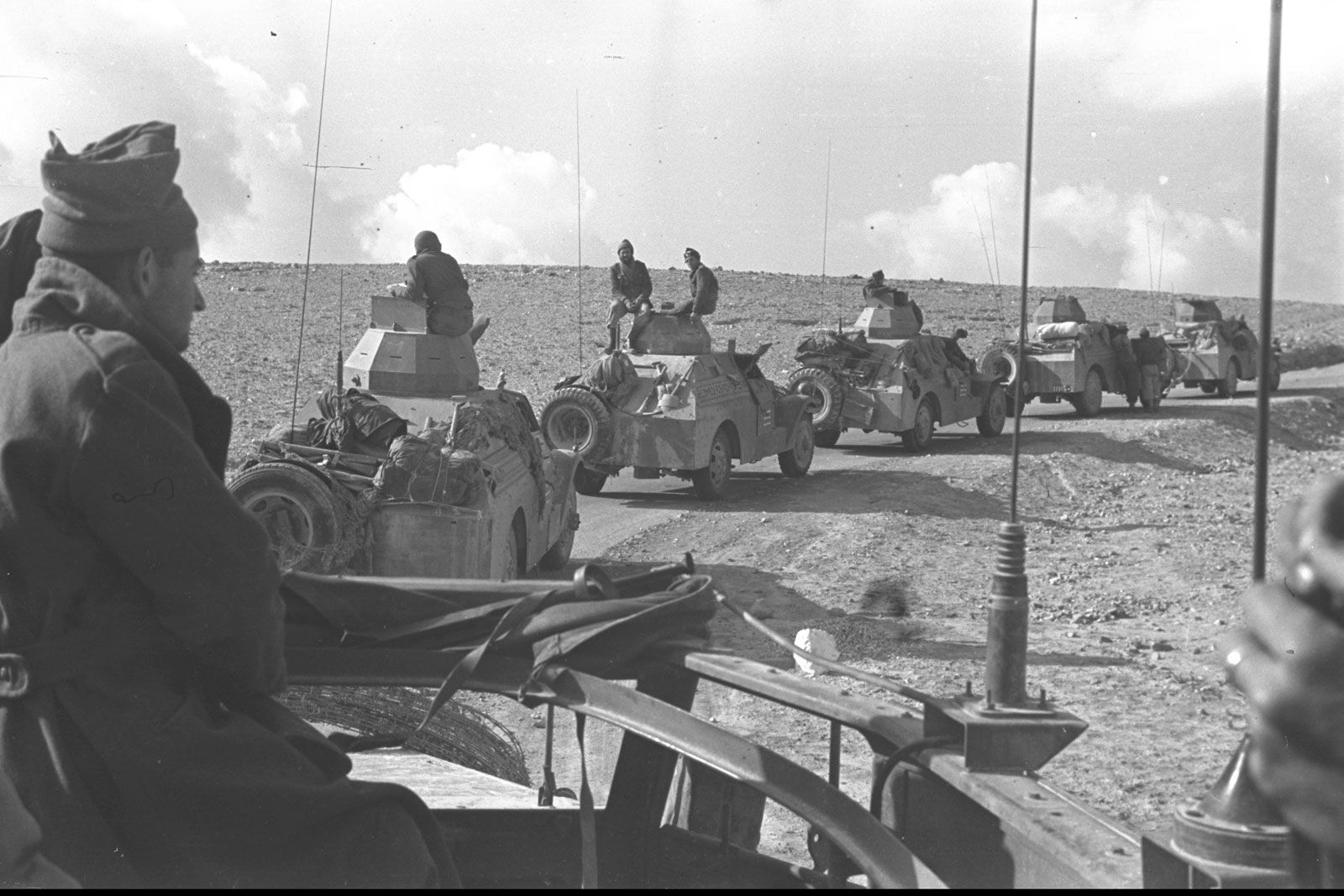
وتحمل القلعة أيضاً أهمية تاريخية كبيرة في الصراع اللبناني – الإسرائيلي. ففي حزيران عام 1982 شهدت واحدة من أشهر معارك الاجتياح الإسرائيلي للبنان، عندما تحصّن داخلها نحو 30 مقاتلاً فلسطينياً فقط في مواجهة أكثر من 1200 جندي إسرائيلي مدعومين بالدبابات والطائرات والمدفعية.
واستمرت المعركة عدة أيام وكبّدت القوات الإسرائيلية خسائر كبيرة، قبل أن يتمكن الجيش الإسرائيلي من السيطرة على القلعة. وتروي المصادر الإسرائيلية أن وزير الدفاع آنذاك أريئيل شارون وصل إلى الموقع بعد انتهاء المعركة ليُفاجأ بأن عدد المدافعين كان محدوداً جداً مقارنة بحجم القوة التي خاضت الهجوم.
وبعد احتلالها، تحولت القلعة إلى موقع عسكري متقدم للجيش الإسرائيلي طوال سنوات الاحتلال. وأصبحت الطريق المؤدية إليها تُعرف داخل إسرائيل باسم «الطريق الدامي» بسبب كثرة العمليات والهجمات التي استهدفت القوات الإسرائيلية على هذا المحور.
وعندما قررت إسرائيل الانسحاب من جنوب لبنان عام 2000، أخلت القلعة بسرية قبل أن تقوم بتفجير أجزاء منها لمنع الاستفادة العسكرية منها بعد الانسحاب.
واليوم، تعود الشقيف إلى دائرة الاهتمام العسكري بسبب قدرتها على توفير نقطة إشراف نارية واستخباراتية واسعة، تسمح بمراقبة أجزاء كبيرة من جنوب لبنان والتحكم بقدر مهم من الحركة الميدانية في المنطقة. ولهذا السبب لا يُنظر إليها كمجرد معلم أثري أو قلعة تاريخية، بل كواحدة من أهم العقد العسكرية والجغرافية في الجنوب، والتي ظلّت محور صراع منذ أكثر من أربعة عقود.
Despite more than four decades having passed since the famous Battle of Beaufort Castle, the fortress remains one of the most important military positions in southern Lebanon. With every escalation or confrontation in the region, it returns to the spotlight as a site capable of influencing the balance of battlefield control thanks to its geographical location and long military history.
Beaufort Castle, known locally as the Shqif Castle, is considered one of the most strategic locations in southern Lebanon because of its unique geographic position. Standing more than 700 meters above sea level, it offers exceptional oversight of vast areas of southern Lebanon and northern Israel. From its walls, observers can monitor the Litani River, numerous southern villages and towns, and the main routes linking Nabatieh, Marjayoun, and the eastern sector of the south.
The fortress directly overlooks Arnoun, Kfar Tebnit, Yohmor, Zawtar, Taybeh, Deir Siryan, and Qantara, as well as the settlement of Metula, located less than four kilometers away. This gives it significant intelligence and military value, allowing for the monitoring of movements, supply routes, and force deployments across a wide area.
Its importance is not limited to its elevation. The castle also overlooks the Litani River and the Wadi al-Slouqi valley, two of the most important military corridors in southern Lebanon. Military planners therefore regard it as a key commanding position, since whoever controls it enjoys greater capabilities for observation, direction, and control over movement routes in the surrounding area.
The fortress also holds major historical significance in the Lebanese-Israeli conflict. In June 1982, it witnessed one of the most famous battles of the Israeli invasion of Lebanon, when approximately 30 Palestinian fighters defended the castle against more than 1,200 Israeli troops supported by tanks, aircraft, and artillery.
The battle lasted several days and inflicted significant losses on Israeli forces before the castle eventually fell. Israeli accounts later reported that then-Defense Minister Ariel Sharon visited the site after the battle and was surprised to learn how few defenders had held off such a large attacking force.
Following its capture, the castle became an advanced military position for the Israeli army throughout the years of occupation. The road leading to it became known in Israel as the “Bloody Road” because of the numerous attacks carried out against Israeli forces along that route.
When Israel withdrew from southern Lebanon in 2000, it secretly evacuated the castle before demolishing parts of it to prevent its future military use.
Today, Beaufort Castle has once again become a focus of military attention because of its ability to provide a wide intelligence and fire-control vantage point, allowing oversight of large portions of southern Lebanon and influence over a significant share of military movement in the area. For this reason, it is viewed not merely as a historical landmark or ancient fortress, but as one of the most important military and geographical nodes in southern Lebanon, remaining at the center of regional conflict for more than four decades.